 |
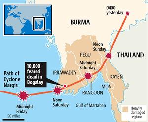
| Click Image To Enlarge: Track of NARGIS |
|
|
 |
| Click To Enlarge: Path of Nargis |
|
|
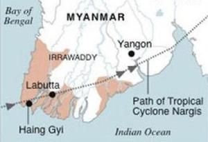 |
| Click To Enlarge: 2nd View of Nargis Path |
|
|
|
|
What The Decanates Have To Say
- The Destruction of Physical Structures; Thoroughfares Blocked
- Warnings of Danger
- A Place & Time of Adversity
- An Appointment With Death ... "An Arrow Finds Its Mark"
- Aftermath: The Days Following Death
- A Great Tragedy
- Fleeing the Scene of A Catastrophe
- Recovering Lost People
- Weather Threats; Hurricanes & Great Storms
|
 |
| Click Image To Enlarge Radix Chart |
|
|
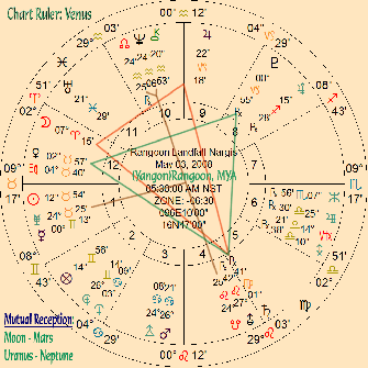 |
| Click Image To Enlarge: Nargis Makes Landfall At Rangoon |
|
|
- In Rangoon (Yangon), all the roads are blocked, there is no electricity, & there is no water. Hundreds of houses lost their roofs...Hospitals are ruined, at least 90,000 people are left homeless.
- This country has a lot on its plate. A new Constitution and a follow-up general election is still on the agenda...supposedly "on the road to Democracy"; Burma is currently run by a repressive military regime or "Junta".
- Aid workers are saying that two - three million people are now homeless in Burma & 50,000 have died so far.
|
What The Decanates Have To Say
- A Great Tragedy
- A Beleaguered City
- Armed Forces or Military Deployments
- A subversive Group
- Committee Findings
- Hurricane & Heat
- Great Resolve in Dealing With Unpleasant Matters
- Explosions
- Vigilance, To Be on Alert for the Anticipated. The Anticipated Occurs
| NOTES:
- The Vertex is this chart is in the same Decanate as the Indicator
for Hurricane Katrina (2nd Libra)
- The 5th & 11th Houses are Intercepted: Indicating that the Government is at odds within itself in dealing with this problem ... that one faction is conservative or reacionary and the other is either radical or progressive.
This did in fact turn out to be the case.
|
- Often, with a Hurricane, it primarily can be a wind event or a Flood Event...sometimes its both...Nargis packed 120 mph winds, but its storm surge is credited with most of the Damage....a "flood event".
- Below is the Island / Peninsula Country of Burma (Myanmar) showing the before & after photos. As you can see, Burma is now essentially Under the Water....not above it:
↓
|
 |
| This is Burma before Nargis. The Red Square shows the location of Rangoon (Yongan) |
|
|
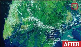 |
| After Nargis, Burma is essentially...Underwater |
|
|
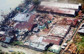 |
| This was a Factory. After Nargis; well ... (photo AFP) |
|
|
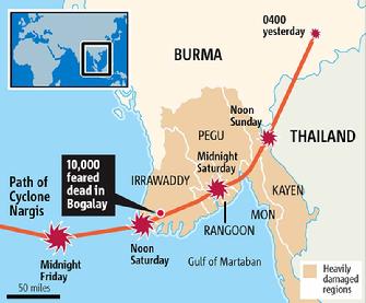 |
| Here is another Nargis Track Map from The Daily Mail |
|
|
| Satellite Views of Nargis |
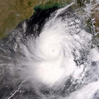 |
| NARGIS |
|
|
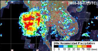 |
| Satellite from Sentinel Asia (by BBC) |
|
|
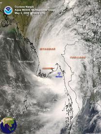 |
| Click To Enlarge: Satellite View of Nargis: 03 May 2008 |
|
|
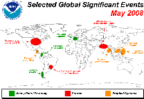 |
| Click To Enlarge: Events of May 2008 |
|
|
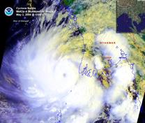 |
| Click To Enlarge: Satellite View of NARGIS: 02 May 2008 |
|
|
NOTES:
- Tropical Cyclone Nargis, the most devastating cyclone to strike Asia since 1991 (Reuters), developed in the Bay of Bengal on April 27. Prior to making landfall in Burma (Myanmar)
- On May 2, the cyclone intensified to a very severe cyclonic storm (equivalent to a category 4 in the Saffir-Simpson scale) with peak winds near 213 km/hr (132 mph or 115 knots).
- Nargis, the first tropical cyclone to strike Burma (Myanmar) since Cyclone Mala in 2006 and the first cyclone to develop in the Bay of Bengal since Cyclone Sidr (BBC News), swept through the Irrawaddy delta region and Yangon (Rangoon), the country's largest city.
- The storm brought heavy rain, strong winds, and a 3.7 meter (12 foot) storm surge, resulting in the worst disaster ever in the country (Associated Press).
- The cyclone destroyed thousands of homes and left thousands without power (Associated Press).
- According to early reports, the cyclone left nearly 78,000 people dead and almost 56,000 missing (Reuters), but it has also been reported that the death toll may eventually exceed 100,000 (CNN).
|
|
|