| "A California Firefighter: 'Nuf Said!" |
Is a Picture Worth a Thousand Words?
Below are pictures with a couple of words under each one,
just for good measure.
CLICK ON THE IMAGES BELOW TO ENLARGE THEM,
And See For Yourself ...
|
|
|
SOUTHERN CALIFORNIA WILD FIRES
BEGAN: 26 AUGUST 2009
"About" 3:30 PM PDT
|
|
 |
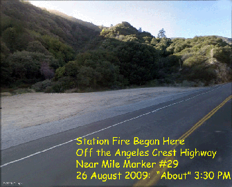
| On August 26th about 3:30 PM: The Station Fire Began ... here: |
|
|
 |
| Click Image to Enlarge |
|
| SUSPECTED ARSON
- The origin of the Station Fire is now believed to be arson. The ignition site is off the Angeles Crest Highway near Mile Marker 29 where incendiary materials were found:
- LONG: 118º W 11' 41"
- LAT: 34º N 15' 04"
|
|
 |
| Click Image to Enlarge Data Map |
|
|
 |
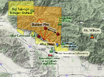
| Click Image to Enlarge Station Fire Close-Up |
|
| More Coordinates:
- Station Fire (La Canada Flintridge):
34º N 14' 59" / 118º W 11' 57"
- North of Alta Dena:
34º N 14' 12" / 118º W 09' 32"
- Alta Canyada Road Fire Fighter's Fire Line
34º N 13' 55" / 118º W 12' 33"
|
|