| MENU List Below : KATRINA, GUSTAV & IKE ... |
- Landfall: Grand Isle, Louisiana
|
- Landfall: WSW of Cocodrie, Lousiana
- Time:
08:15 AM CDT (*see satellite loop below)
|
- Landfall: Galveston Island, Texas
|
|
- NOTE: Hurricane Rita was the fourth–most intense Atlantic hurricane ever recorded and the most intense tropical cyclone ever observed in the Gulf of Mexico. Part of the record-breaking 2005 Atlantic hurricane season, which included three of the six most intense Atlantic hurricanes ever (along with #1 Wilma and #6 Katrina), Rita was the eighteenth named storm, tenth hurricane, and fifth major hurricane of the 2005 season. Rita formed near The Bahamas from a tropical wave on September 18 that originally developed off the coast of West Africa. It moved westward, and after passing through the Florida Straits, Rita entered an environment of abnormally warm waters. It rapidly intensified to reach peak winds of 180 mph (285 km/h) on September 20. After steadily weakening and beginning to curve to the northwest, Rita gradually weakened and made landfall on Sabine Pass, Texas with winds of 120 mph (195 km/h) on September 24. It weakened over land and degenerated into a large low-pressure area over the lower Mississippi Valley on September 26.
In Louisiana, the storm surge from Rita inundated low-lying communities near the coast, worsening effects caused by Hurricane Katrina less than a month prior. The surge topped levees, allowing water to surge further inland. Lake Charles suffered from severe flooding. Areas in Texas suffered from extensive wind damage. Baton Rouge experienced Rita as prmarily a wind event.
( Click Here For Rita wiki page)
|
 |
| KATRINA CAT- 3 |
|
|
|
|
 |
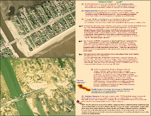
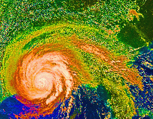
| Click To Enlarge: Katrina Making Landfall on 29 August 2005: This Satellite image shows Katrina moving to the East of New Orleans & the Lake Ponchatrain's North Shore thus presenting its "dry side" to the Crescent City. New Orleans residents believed they had "dodged the Katrina bullet", and; then... the Levees gave way & eyewitnesses actually reported Sharks "swimming through the streets of The French Quarter" |
|
|
 |
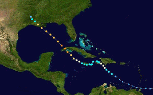
| Katrina's Track: Click Image To Enlarge |
|
|
K A T R I N A
- Hurricane Katrina was one of the strongest storms to impact the coast of the United States during the last 100 years. With sustained winds during landfall of 125 mph (110 kts; a strong category 3 hurricane on the Saffir-Simpson scale) and minimum central pressure the third lowest on record at landfall (920 mb), Katrina caused widespread devastation along the central Gulf Coast states of the US. Cities such as New Orleans, LA, Mobile, AL, and Gulfport, Mississippi bore the brunt of Katrina's might.
- Hurricane Katrina developed initially as a tropical depression (TD #12 of the season) in the southeastern Bahamas on August 23rd. This tropical depression strengthened into Tropical Storm Katrina the next day. It then moved slowly along a northwesterly then westerly track through the Bahamas, increasing in strength during this time.
Florida: A few hours before landfall in south Florida at around 6.30 EDT on August 25th, Katrina strengthened to become a category 1 (windspeeds of 75mph or greater) hurricane. Landfall occurred between Hallandale Beach and North Miami Beach, Florida, with windspeeds of approximately 80 mph (70 kts). Gusts of above 90 mph (78 kts) were measured as Katrina came ashore. As the storm moved southwest across the tip of the Florida peninsula, Katrina's winds decreased slightly before regaining hurricane strength in the Gulf of Mexico. Given that Katrina spent only seven hours over land, its strength was not significantly diminished and it quickly re-intensified shortly after moving over the warm waters of the Gulf. On the afternoon of August 26th; Katrina attained major Hurricane status.
- Continuing to strengthen and move northwards during the next 48 hours, Katrina reached maximum windspeeds on the morning of Sunday August 28th of over 170 mph (150 kts, category 5), and its minimum central pressure dropped that afternoon to 902 mb - the 4th lowest on record for an Atlantic storm. Although Katrina, at its peak strength was comparable to Camille's intensity, it was a significantly larger storm and impacted a broader area of the Gulf coast.
- Although tropical cyclones of category 5 strength are rarely sustained for long durations (due to internal dynamics), Katrina remained a strong category 4 strength hurricane despite the entrainment of drier air and an opening of the eyewall to the south and southwest before landfall on the morning of the 29th .
Landfall windspeeds at Grand Isle, LA were approximately 125 mph (110 kts) (strong category 3 intensity) with a central pressure of 920mb - the 3rd lowest on record for a landfall for an Atlantic storm in the US.
- Eastern Florida - Rainfall:
During its initial landfall in southern Florida, Katrina generated over 5 inches of rainfall across a large area of southeastern Florida. An analysis by NOAA's Climate Prediction Center shows that parts of the region received heavy rainfall, over 15 inches in some locations, which caused localized flooding.
Winds at landfall north of Miami were 80 mph (category 1 strength), leading to some damage and extensive power outages.
The U.S. Gulf Coast - Rainfall:
Rainfall from Katrina's outer bands began affecting the Gulf coast well before landfall. As Katrina came ashore on August 29th, rainfall exceeded rates of 1 inch/hour across a large area of the coast. NOAA's Climate Reference Network Station in Newton, MS (60 miles east of Jackson, MS) measured rainfall rates of over an inch an hour for 3 consecutive hours, with rates of over 0.5 in/hr for 5 hours during August 29th. Precipitation analysis from NOAA's Climate Prediction Center show that rainfall accumulations exceeded 8-10 inches along much of the hurricane's path and to the east of the track.
Windspeeds over 140 mph were recorded at landfall in southeastern Louisiana while winds gusted to over 100 mph in New Orleans, just west of the eye. As the hurricane made its second landfall on the Mississippi/Louisiana border, windspeeds were approximately 110 kts (125 mph). Gusts of over 80mph were recorded in Mobile and 90 mph in Biloxi, MS.
The central pressure at landfall was 920 mb, which ranked 3rd lowest on record for US-landfall storms behind Camille (909 mb) and the Labor Day hurricane that struck the Florida Keys in 1935 (892 mb). Hurricane Andrew in 1992 dropped to fourth, as its central pressure was 922 mb at landfall. Katrina also reached a minimum central pressure of 902 mb at its peak, ranking 4th lowest on record for all Atlantic basin hurricanes.
Inland - Rainfall:
As the storm moved inland and weakened to a tropical storm on the 29th, rainfall became the primary impact. Rainfall amounts exceeded 2-4 inches across a large area from the Gulf coast to the Ohio Valley. As a result, flood watches and warnings were common across these regions. Rain bands from Katrina also produced tornadoes causing further damage in areas such as Georgia.
|
|
| 3 Bad HURRICANES in 2008 |
|
|
|
|
G U S T A V
AND
I K E
|
 |
| Click Image to Enlarge: 3 Hurricanes ... all in a row. Gustav" making Landfall & Ike with its "eye" on Galveston; all headed for the U.S. Gulf Coast |
|
|
 |
| Click On Image To Enlarge Data |
|
|
|
| GUSTAV: CAT- 4 |
|
|
|
|
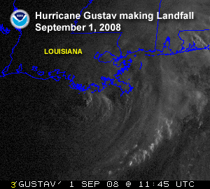 |
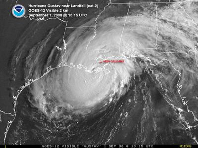
| Gustav Makes Landfall |
|
| Gustav's Landfall
- At 8:00 AM CDT: Gustav was at: 28� N 54' / 90� W 24'
- At 10:00 AM CDT: Gustav was at: 29� N 12' / 09� W 48' (over the coastline and west south west of Cocodrie, LA.) with winds at 116 mph. (Note: between 10:00 AM & 10:30 AM, the power started to go out in Baton Rouge & phone lines began to stop working)
- At Noon: Gustav was at: 29� N 36' / 91� W 06' (10 miles Southeast of Morgan City)
- Baton Rouge, Louisiana: 30� N 26' / 91� W 11'
|
Gustav formed off of Port-au-Prince Haiti
|
 |
| Gustav at Landfall-Satellite View |
|
|
 |
| Gustav Almost at Landfall ... |
|
|
 |
| Click Image To Enlarge: Gustav's Track right through Baton Rouge, LA. |
|
|
 |
| Click To Enlarge: Gustav making Landfall |
|
|
|
| IKE: CAT - 2 |
|
|
|
|
- By September 9, Ike emerged into the southern Gulf of Mexico as a Category 1 hurricane. The unusually large storm produced hurricane force winds as far as 193 km (120 miles) from the center and tropical storm force winds extending 445 km (275 miles).
- The large wind field caused tides around Galveston Island to rise as much as nine feet 24 hours before the storm made landfall.
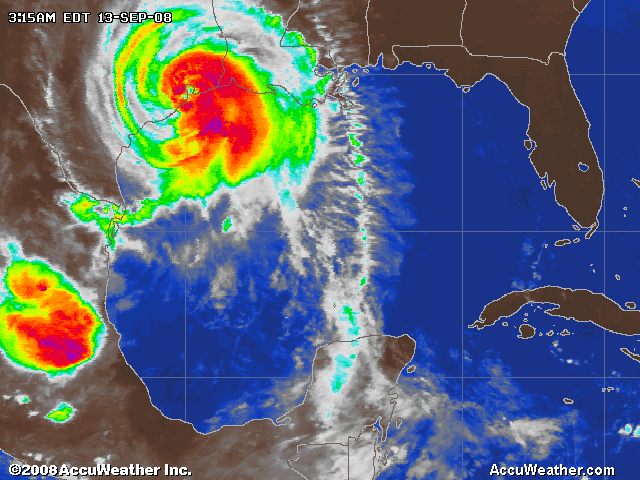
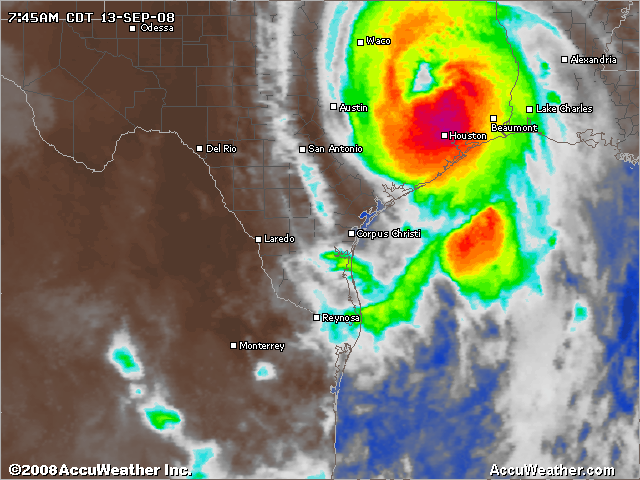
When Hurricane Ike made landfall at Galveston Island during the early morning hours of September 13, its winds were sustained at 176 km/h (95 knots or 109 mph) and the pressure was at 952 mb, enough to be a strong Category 2 hurricane. At the time of landfall, wind speeds 300 feet above the land's surface were measured at 130 mph
- These strong winds caused major damage to the high rise buildings in the downtown Houston area as well as some of the oil refineries in Texas City. Already suffering from the destruction that Hurricane Gustav created, the Gulf Coast oil companies had nearly 100% of its crude oil production, as well as 98% of all natural gas production disrupted from Ike (Associated Press).
- Storm surge was the major cause of damage associated with Ike as tidal gauges in the northwestern Gulf registered well above normal during a 3-day period. Some of the hardest hit areas were just north of Galveston on the Bolivar Peninsula where the towns of Crystal Beach, Caplen, and Gilchrist were destroyed.
- The storm surge in Louisiana was 5-13 feet. Terrebonne Parrish, which was not flooded from a direct hit by Hurricane Gustav, lost approximately 13,000 homes.
|
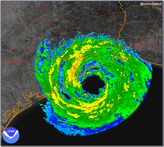 |
| Ike Makes Landfall on Galveston Island |
|
|
 |
| 2:10 AM CDT at Galveston Island on 13 Sept 2008 |
|
|
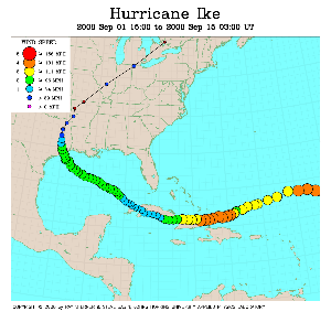 |
| Click On On Image To Enlarge: IKE"s Track |
|
|
 |
| Click Image To Enlarge: Ike over Cuba |
|
|
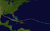 |
| Click Image To Follow Ike's Track |
|
|
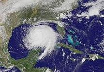 |
| "IKE" in the Gulf of Mexico... its size ecompasses almost the entire Gulf of Mexico |
|
|
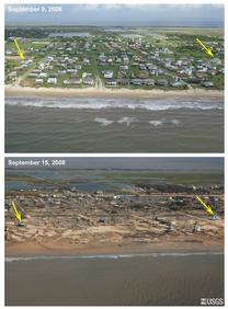 |
| Click Image to Enlarge: Before & After Galveston |
|
|
 |
| BELOW: Related Info & Data |
|
| Includes:
- Chart of 2005 Hurricanes
- Track: Hurricane Kyle
- Gustav: Related Chart Hits
- Katrina: Related Info & Chart Hits
|
|
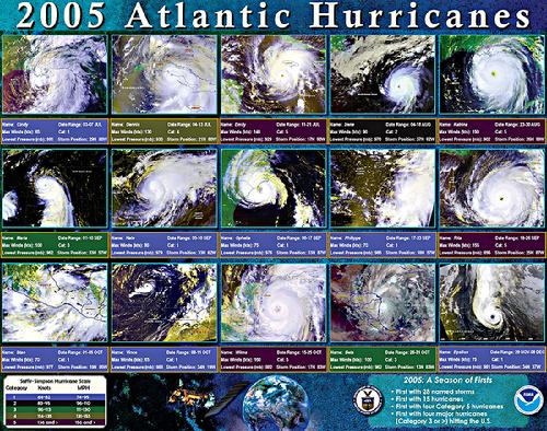 |
| 2005 Atlantic Hurricanes (click to enlarge) |
|
|
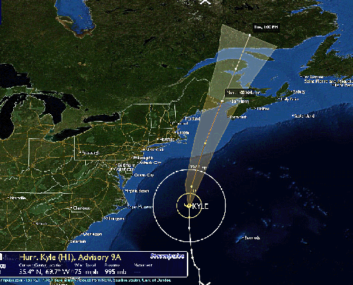 |
| Click Image to Enlarge Kyle |
|
|
Don't Miss This!
→
|
G U S T A V
In the Current Solar Eclipse Chart (01 July 2008):
"Nature's Great Happenings"
= 54� 13'
In the Current Lunar Eclipse Chart (16 August 2008):
The Eclipse = 54� 21'
and
Nature's Great Happenings
= 53� 32'
In the Current Lunation Chart (New Moon 30 August 2008):
The Midpoint of the Moon / The State of Louisiana
= 53� 22'
|
KATRINA
- Pre - SOLAR ECLIPSE: 19� Aries 06' - April 08, 2005
GMT~ 20:32:20
- LUNATION: Last Quarter: 03� Gemini 29' - Aug. 26, 2005
GMT~ 15:19:00
- New Orleans Natal Data: 17 Feb 1805 (Carolyn Dodson)
(founded May 07, 1718)
LONG: 90� W 04' / LAT: 29� N 57' 16"
- The French Quarter: 29� N 37' 53"/ 90� W 04' 18"
- Louisiana: Admission to the Union: April 30th, 1812
OTHER DATES:
- Louisiana Purchase: December 20, 1803 (France turned over the Louisiana Territory at "The Cabildo" : 29� N 57' 26" / 90� W 03' 51")
- October 20, 1803: U.S. Senate ratifies Louisiana Territory Treaty
- November 29, 1803: Formal Ceremony transferring Louisiana Territory from Spanish to French (held in New Orleans)
- March 10th, 1804: Louisiana Territory officially turned over the the United States in a ceremony held in St. Louis; the U.S. was represented by Freemason Merriwether Lewis of "Lewis & Clark" fame and the first governor of Louisiana. His death at 35 on his way to Washington, DC to collect money from the War Department on drafts he had drawn as governor of Louisiana ... which had been denied... has remained a mystery. Was it suicide or murder?
- Oct 01, 1804: This "turnover" Treaty became "Effective" as the "Orleans Territory" & "The District of Louisiana"...but under the control of Indiana
- Battle of New Orleans: December 23, 1814 - January 26th, 1815
|
|
|
|