NOTE: This page still getting additions & updates
|
|
|
 |
| Click Image To Enlarge |
|
|
|
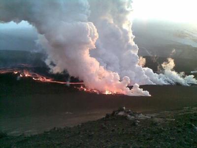 |
| Click To Enlarge: New Vents open up on 31 March 2010 |
|
|
A 6.3 Earthquake occurred on May 29th, 2008 .... Iceland was waking up.
- The Icelandic coast of Reykjanes is where the Mid-Atlantic Ridge rises above sea level. Increased seismicity on the Reykhanes Ridge, suggested the possibility of magma movement and as a result .... a volcanic eruption on Iceland.
- A lot of seismic activity uner Eyafjallajökull indicated the possibility of activity at Eyjafjallajökull. There was an especially large uptick at the beginning of March 2010 in both the number and magnitude of the quakes which were reaching around M3 almost directly underneath the ice-buried crater of the volcano.
This would suggest that something is up under the ice cap By the end of March, new vents were opening up
|
|
| "... it looks like Eyjafjallajökull is a prime candidate for the next eruption on Iceland"
Posted on: March 4, 2010 8:41 AM, by Erik Klemetti
- Eyjafjallajökull (also known as merely Eyjafjöll) is one of a series of volcano systems on the south side of Iceland, near Katla. Amongst the Icelandic volcanoes, it has been relatively quiet, with the last known eruption occurring from 1821 until 1823, with evidence for eruptions in 1612 and 550 AD.
- The last two eruptions have been VEI 2, with explosive characteristics - and with a volcano under a glacier, we always have the threat of jökulhlaup - glacial outburst flows triggered by the volcanic eruption.
- And unlike many Icelandic volcanoes, the last eruption of Eyjafjallajökull was produced silicic to intermediate tephra rather than basalt. The larger volcanoes on Iceland such as Eyjafjallajökull,
- Katla and Krafla have all produced rhyolite eruptions in the dominantly basaltic land - and the rhyolite magma that was hit while drilling last year shows that you can get very silicic magmas even in a hot spot / mid-ocean ridge setting.
[Hat tip to Dr. Boris Behncke and Mattias Larsson for info in this post.]
|
QUICK TIME LINE:Eyjafjallajökull eruption: 20 March to present
Compiled by Freysteinn Sigmundsson
Information sources: Nordic Volcanological Center, Institute of Earth Sciences; Icelandic Meteorological Office (seismic and hydrological observations) and many others.
- 20 March, late evening: An eruption begins on Fimmvörðuháls located between the Eyjafjallajökull and Mýrdalsjökull ice caps. The eruption was initially detected visually; a red cloud above eruptive site was seen around 23 GMT. The onset of the eruption was gentle, following a period of weeks and months prior to the eruption of high seismic activity and high crustal deformation rates in the Eyjafjallajökull volcanic system. Seismic tremor begins around 22:30 and rises gently. Seismicity was not enhanced significantly immediately prior to the eruption compared to the weeks prior to the eruption. However, the depth of earthquakes decreases and earthquake propagate from magma upwelling area under Eyjafjallajökull towards the eruptive site.
- 21 March: Observations from air in early morning reveal a short (<500 m) NE-SW oriented effusive eruptive fissure with fire fountaining and Hawaiian eruptive style. Fire fountains occur from 10-12 vents, with lava jets reaching up to about 100 m hight. The eruption appeared stable from 4-7 AM when viewed from air. The eruption tremor rose gently until reaching a maximum around 7-8 AM. No further lengthening of the fissure was detected. Lava is limited to immediate surroundings of the eruptive craters (less than few hundred meters). Minor amount of ash falls within few km to the west of the eruption site, carried by easterly winds. No ice melting is occurring as the eruptive fissure is just outside the ice covers of Eyjafjallajökull and Mýrdalsjökull.
- 22 March: Initial observations from ground. Activity had focused on a series of closely spaced vents. Prevailing easterly winds lead to maximum scoria accumulation on a linear rim west of the NE-SW oriented fissure. Lava flows (Aa type) towards the Hrunagil canyon with initial view on a spectacular „lava fall“ as molten lava flows off steep cliffs into the canyon.
- 23 - 31 March: Steady eruptive activity in initial craters with gradual focusing towards fewer vents. Lava flows towards north into two canyons, Hrunagil and Hvannárgil, with intermittent spectacular „lava falls“ as molten lava flows off steep cliffs into both canyons. Extensive steam plume generation when magma melts snow in front of advancing lava, mostly in the canyons. Two or three plumes observed (one at the eruptive craters, others more pronounced in front of the advancing lava). Meltwater released in batches into rivers in the canyons. Relatively steady eruption tremor recorded by seismometers.
- Evening of March 31: Opening of a new short fissure immediately north of the previous one probably relating to changes at shallow depth in the feeder channel (few hundred meters?). No change in eruption tremor.
- 31 March – April 6: Activity continues in both the old and new eruptive craters, in a similar manner as before, with lava mostly flowing towards the NE, and pronounced „lava falls“ in Hvannárgil. Last active phase of the of the lava fall into Hrunagil on 31 March.
- April 5: Eruption tremor (1-2 Hz frequency band at nearest seismic station Godabunga) begins to decline in a gradual manner.
- April 7: Activity has stopped in the original craters of the eruption, and is limited to craters on the new fissure formed on 31 March. Lava flows cover an estimated area of 1.3 square kilometers, with estimated average thickness of 10-20 m. Maximum elevation of scoria craters formed in the eruption is 82 m.
- April 9: After little change in deformation rates during the eruption, timeseries at continuous GPS-stations north of the volcano show sudden change, partly jumping back to pre-eruptive levels. Signals may relate to decreasing pressure in the magma conduit feeding the eruption.
- April 11: Eruption tremor approaches pre-eruptive levels, but visual observation reveal eruptive activity in late afternoon.
- April 12: Seismic tremor reaches a minimum - eruption temporarily stops
- April 13: Extensive seismic swarm begins around 23:00 under the central part of Eyjafjallajokull.
- April 14: Onset of seismic tremor shortly after midnight of increasing amplitude, in association with an eruption from a new vent under the central ice-capped crater of Eyjafjallajokull. The eruption is visually confirmed in early morning - eruption plume rises above Eyjafjallajokull. Meltwater forms a jokulhlaup.
- April 15: Explosive eruption continues. Eruption plume reaches mainland Europe with closure of airspace over large part of Northern Europe, including UK and Scandinavia. Eruption tremor continues at similar level.
|
Unfolding of Events continues below:
↓
|
|
Report From the Nordic Volcano Center
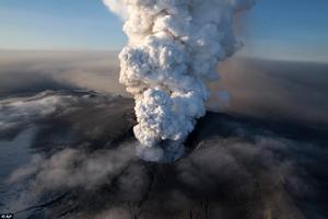
- Explosive eruptive phase of the Eyjafjallajökull volcano, Iceland, begins 14 April 2010. The eruption plume from Iceland that has caused the unprecedented catastrophic disruption of air traffic and closure of airspaces over northern Europe is due to an explosive eruptive phase that began at the Eyjafjallajökull volcano on April 14.
- It is a continuation of eruptive activity in the Eyjafjallajökull volcanic system that began 20 March 2010. During an initial eruptive phase from 20 March to 12 April lava flowed from eruptive vents on the volcano flanks, outside its ice cover. The lava erupted in the initial phase is alkali-olivine basalt, with silica content of about 47%.
- After a short hiatus in eruptive activity a new set of craters opened up in early morning of 14 April under the volcano's ice covered central summit caldera. This eruptive phase was preceded with a swarm of earthquakes from around 23:00 on 13 April to 1:00 on 14 April.
- The earthquake swarm was followed by the onset of seismic eruption tremor. Meltwater started to emanate from the ice cap around 7 o'clock on April 14 and eruption plume was observed in the early morning.
- Visual observations were limited by cloud cover over the volcano, but an airplane of the Iceland coast Guard imaged with eruptive crates with radar instrument. Series of vents along a 2 km long north-south oriented fissure were active, with meltwater flowing down northern slopes of the volcano, but also to the south. Ash loaded eruption plume rose to more than 8 km height, deflected to the east by westerly winds.
- Jokulhlaups (floods of meltwater) reached the lowlands around the volcano with peak flow around noon on April 14, with destruction of roads, infrastructure, and farmlands. No fatalities as people had been evacuated from hazardous areas. Tephra fall begins in southeast Iceland.
- A second jokulhlaup/lahar emanates from the ice cap down the Markarfljot valley in the evening.
- On 15 April the eruption plume reaches mainland Europe with closure of airspace over large part of Northern Europe. Activity continues at a similar level with ash generation and flow of meltwater in pulses. Jokulhlaup/lahar occurs in the evening.
- On April 16 some variability occurs in seismic tremor and tephra generation, but overall the eruptive activity remains stable. Pulsating eruptive plume reaches above 8 km, with overall height of 5 km. Large closures of airspace continue.
- Chemical analyses of ash samples reveal fluorine rich intermediate eruptive products with silica content of 58%, more evolved than in the initial lava producing phase of the eruptive activity. The magma composition may reflect evolution from alkali-olivine basalt by crystal fractionation as erupted in the initial phase.
|
"NEW PHASE STARTS"Again, this refers to the origin of the present Eruption
- Eyjafjallajökull eruption: A new phase started on 14 April 2010
- A new phase of the Eyjafjallajökull eruption started around midnight on the 14th of April,where melt penetrated its way to the central crater beneath the glacier.
|
|
Eruption in Iceland at the Eyjafjallajökull
volcanic system begins 20 March 2010
- An eruption began in South Iceland in late evening of 20 March 2010 at the Eyjafjallajökull volcanic system (also known as Eyjafjöll volcano – Global Volcanism Program Volcano number 1702-02=).
- The initial visual report of the eruption was at 23:52 GMT, when a red cloud was observed at the volcano, lightening up the sky above the eruptive site. The eruption was preceded with intense seismicity and high rates of deformation in the weeks before the eruption, in association with magma recharging of the volcano. Immediately prior to the eruption the depth of seismicity had become shallow, but was not significantly enhanced from what it had been in the previous weeks. Deformation was occurring at rates of up to a centimetre a day since March 4 at continuous GPS sites installed within 12 km from the eruptive site.
- The eruption broke out with fire fountains and Hawaiian eruptive style on about 500 m long NE-SW oriented eruptive fissure at 63º N 38' 06" / 19º W 26' 24"; on the northeast shoulder of the volcano at an elevation of about 1000 m. It was observed from air from 4-7 A.M. on March 21.
- Lava flows short distance from the eruptive site, and minor eruption plume at elevation less than 1 km was deflected by wind to the west.
- Volcanic explosive index (VEI) is 1 or less. Tephra fall is minor or insignificant.
- The eruption occurs just outside the ice cap of Eyjafjallajökull, and no ice melting is occurring at present.
|
| Evacuations began on 14 April 2010: at 2:00 AM local time (GMT) |
Second phase of Eyjafjallajökull Eruption
- "After a brief hiatus during which the first two fissuers at Fimmvörðuháls closed, the main caldera at Eyjafjallajökull let rip early in the morning of April 14th."
Posted by Steinn Sigurðsson at 12:36 AM
Note: The "tourista" eruptions had been in progress thru April 8th, 2010
|
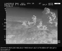 |
| Click Image To Enlarge: The steam and ash plume from the Eyjafjallajökull subglacial eruption that started early morning, April 14, 2010. |
|
|
 |
| Click Image To Enlarge |
|
|
 |
| Click Image To Enlarge |
|
|
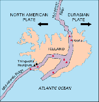 |
| Click Image To Enlarge Tectonic Plates Under Iceland |
|
|
|
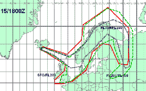 |
| Click Image To Enlarge: Projection of Volcanic Ash Dispersion: 15 April 18:00 GMT |
|
|
- REYKJAVIK, Iceland — A volcano erupted near a glacier in southern Iceland, shooting ash and molten lava into the air and forcing the evacuation Sunday of hundreds of people from nearby villages.
- There were no immediate reports of injuries or damage from the Eyjafjallajokull volcano, but a state of emergency was declared and scientists feared the eruption could trigger a larger and potentially more dangerous eruption at the Katla volcano.
- The April 14th Eruption occurred "early in the morning of the 14th". The current eruption was heralded by a series of earthquakes that began on April 12th. This major eruption began on the 14th. Below is a graph showing the onset.
|
 |
| Click Image To Enlarge: Current Eruption Photo |
|
|
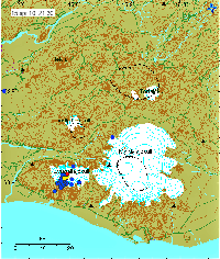 |
| Click Image To Enlarge: Earthquake Map |
|
|
 |
| Click Image To Enlarge: Graph |
|
|
|
Eyjafjallajökull subglacial eruption started early morning on April 14th. The first evacuations began at 2 a.m. (10 p.m. ET Tuesday),
according to Rognvaldur Olafsson, chief inspector at Iceland's Department of Civil Protection and Emergency Management
- After the original fissures ceased activity, the magma found a new route to the surface, this time underneath the Eyjafjallajökull glacier.
- An earthquake swarm underneath the icecap prompted Icelandic officials to start evacuating people from the area around the volcano due to fears for "joklhlaups" (volcanically-triggered glacial floods). These floods can be very powerful, moving car-to-house sized material with ease.
- Reports indicatethe Eyjafjallajökull glacier has created a hole/crater ~200 meters wide deep. Gunnar Gudmunsson of the Icelandic Met Office thinks most of the eruption is occurring at or near the summit of the volcano underneath the ice cap. This has, of course, lead to intense melting of the glacial ice, raising water levels in drainages leading from the volcano in some cases 3 meters in a matter of hours. The south of Iceland has been told to expect flooding due to the eruption. The walking bridge near Fimmvörduháls has also been taken out by the floods, while other measures are being taken to protect roadways.
- The London VAAC message suggests that the eruptive plume from the eruption is at least 8000 meters tall - now this plume is likely dominantly steam with some minor ash component. The fragmentation of the lava in this situation comes from the interaction with water (mostly), so it is different that a very ash-rich Plinian ash column, but still it posed a hazard to aircraft - flights below 30,000 feet have been banned from the zones to the north and the east of the volcano.
- [2] - (CNN) Icelandic authorities evacuated about 800 people early Wednesday when a volcano erupted beneath the Eyjafjallajokull glacier. Iceland, a nation of 320,000 people, sits on a large volcanic hot spot in the Atlantic's mid-oceanic ridge. The last time there was an eruption near the 100-square-mile (160 square-kilometer) Eyjafjallajokull glacier was in 1821.
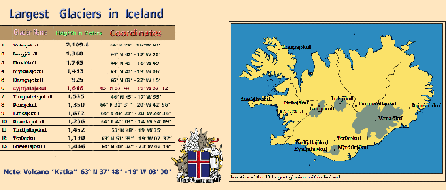
- A bigger worry is the nearby and much larger Katla volcano, which in the past has erupted in tandem with Eyjafjallajokull. Katla is located under the vast Myrdalsjokull ice cap. An eruption could cause widespread flooding and disrupt air traffic between Europe and North America. The last major eruption took place in 1918, and vulcanologists say a new blast is overdue.
|
 |
| Click Image To Enlarge |
|
|
| UPDATES BEGIN HERE STARTING WITH APRIL 15TH, 2010 |
 |
| Click Image To Enlarge: The ash from the Eyjafjallajökull eruption as it spreads over Europe on April 15, 2010 |
|
|
|
U P D A T E:
- London, England (CNN) -- A cloud of ash from a volcano in Iceland swept toward mainland Europe on Thursday, forcing up to 6,000 flight cancellations across the continent, according to the intergovernmental body that manages European air travel
- Thousands of flights were affected as some of Europe's busiest airports closed, including London's Heathrow; Amsterdam, Netherlands' Schiphol; and Paris, France's Charles de Gaulle.
- Volcanic ash can cause jet engines to shut down.
- The prime minister of Norway was among those stranded by the closure of European air space.
- Jens Stoltenberg, who was in the United States for President Obama's nuclear summit, is running the Norwegian government from the U.S. via his new iPad, press secretary Sindre Fossum Beyer said.
- Airspace over the United Kingdom was closed to all flights except emergencies at least until 7 a.m. local time (2 a.m. ET) Friday, Britain's Civil Aviation Authority said. The agency was due to review the situation Thursday evening.
- France, Germany, Ireland, Sweden, Norway, Belgium, Denmark and the Netherlands also announced the complete or partial closure of their airspace, authorities in each country said.
- Norway also closed its ocean territory and canceled helicopter flights to offshore oil installations, according to Avinor, the Norwegian agency responsible for the country's airport network.
- Germany closed the Berlin airport as well as airspace over the city, an airport spokesman said.
- Delta Airlines canceled 65 international flights from its U.S. hubs scheduled over Thursday night and Friday morning. The decision affects flights to Amsterdam; London; Dublin, Ireland; Brussels and Mumbai, India. Whether the airline resumes flights to such destinations will be determined Friday, Delta said.
|
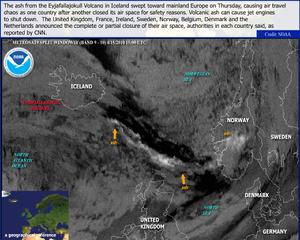 |
| Click Image To Enlarge: Sat. View showing ash with countries affected |
|
| |
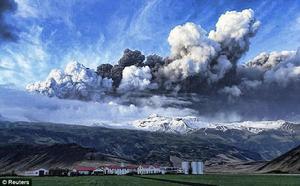 |
| Click Image To Enlarge: Local View showing eruption hovering over landscape |
|
|
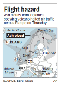 |
| Click Image To Enlarge Map: Flight Hazard: 15 Apr 2010 |
|
|
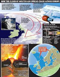 |
| Click Image To Enlarge: Info from the MailOnline (Note: Wed was the 14th - "yesterday" was the 15th) |
|
|
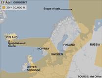 |
| Click Image To Enlarge: Ash Dispersal for April 17, 2010 |
|
|
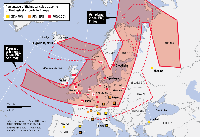 |
| Click Image To Enlarge: WSJ - Copyright © 2010 Dow Jones & Company, Inc. All Rights Reserved. |
|
| Apr 16, 2010 6:31 PM (ET) By MICHAEL TARM
- A volcano erupts in Iceland, and the effects ripple around the globe: A mom in Romania frets about making her son's wedding in Texas. A florist in New York worries shipments won't arrive. Patients awaiting treatment in Nigeria have to wait another week for the doctors.
- The fallout from the ash cloud looming over Europe illustrates just how interconnected our world has become.
- Thousands of planes fly millions of passengers and tons of cargo each day, providing the economic lifeblood of nations and businesses. The flights deliver products for sale or items as small as a specialized tool that lets a factory keep operating.
- The planes also bring medicines to hospitals and food aid to earthquake or hurricane victims. And they bring war and peace. Soldiers are often transported to and from hot spots by air.
- Tales of woe and inconvenience span every social level, from the Norweigian prime minister who got stuck in New York and had to govern using his iPad, to ordinary people who saved money for trips of a lifetime, then had to abandon those plans.
- The eruption was a single act of nature, but it stopped the world in countless ways.
|
 |
| Click Image To Enlarge: Ash Coverage: 17 April 2010 |
|
|
 |
| Click Image To Enlarge: 17 Apr 2010 |
|
|
- BRITAIN: All airspace closed until at least 0600GMT Sunday (2 a.m. EDT Saturday). British Airways canceling all short-haul flights to and from London airports Sunday.
- FRANCE: Paris airports and about two dozen others in northern France will remain closed until at least Monday morning.
- GERMANY: All airspace closed until at least 0000GMT Sunday.
- SWITZERLAND: Swiss air space remains closed until 1800GMT Saturday.
- AUSTRIA: All airspace closed until at least 0000 GMT Sunday, but higher airspace (above 7,500 meters) will be gradually reopened beginning 1800 GMT Saturday.
- BELGIUM: Brussels Airlines canceled all flights until noon Monday. Belgian airspace closure until at least 1800GMT Saturday.
- HOLLAND: All airspace closed until further notice.
- ITALY: Airspace in northern Italy closed until 1800GMT Saturday.
- SPAIN: Iberia canceled all of its European flights - except those linking Spain with Portugal, south Italy, Greece and Istanbul - until further notice.
- NORDICS: All airspace in Sweden and Finland closed until further notice; airspace in Denmark and Baltics closed till at least 0000 GMT. Only airspace in Norway's far north is open. Scandinavian airline operator SAS AB said it has cancelled all flights to and from Denmark, Sweden and Norway for both Saturday and Sunday, except for some domestic flights in northern Norway.
- CZECH REPUBLIC: All air space will remain closed at least till Sunday noon.
- CROATIA: International airports in the capital of Zagreb and in Osijek, in the east, and those in the western parts of the country were all closed.
- SLOVENIA: International airports in Maribor and Portoroz closed.
- SERBIA: The country has closed a small strip of its airspace in the north.
- BELARUS: All flights banned until at least 1300GMT. At the Minsk National Airport most flights to Europe have been cancelled.
- UKRAINE: Kiev's Borispol airport had cancelled all flights until at least 1300GMT.
- RUSSIA: About 185 flights from Russian airports are delayed or have been cancelled.
|
 |
| Ash Advisories: 20 April 2010 - 06:00 AM GMT |
|
|
|
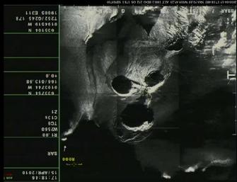 |
| Click Images To Enlarge: original Satellite Image of "face" |
|
|
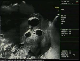 |
| "The Face of Eyjafjallajökull" ... Right Side Up? |
|
|
The World Dial Chart (as posted on AstralNewz) indicates: "The Air and What's In It" .....
This proved to be the main issue during the coming days ...
- hundreds of thousands of airline flights cancelled due to what was in the air....tiny invisible pieces of volcanic glass which could kill jet engines.
The postings are below for Dial Notes & This Lunation Week More can be found on the Dial itself, including the words: "The Air & What's In It"also listed are the formulas that showed up. For example:
- Mercury/Saturn = Uranus: "Travel Disrupted"
- Aries/Pluto = Vulcanus: "A sudden & stormy Development"
- Aries/Vulcanus = Zeus: "A Volcanic Eruption"
- Aries/Admetos = ASC: "The World stymied/at a standstill at certain locales"
- Pluto/ASC = Poseidon: "Unseen Changes or Transformations"
- ASC + Poseidon - Admetos = Lunation/Uranus: "Sudden Invisible particles (or substance) in the air"
- In this Chart: The Volcano's longitude
= Lunation/Neptune and Zeus/Vulcanus (0rbs 01' & 02') which indicates a volcanic eruption, magma or Nature Event
|
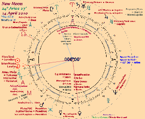 |
| Click Image To Enalrge: New Moon Lunation World Dial Chart - 14 April 2010 |
|
|
Dial Notes Posted for New Moon
- Explosions
... Something "vaporized"
- New
Motor
- Lightning
- Great
Fires ... Fire Damage
- Volcanic
Eruptions
- Sports
Team .... or: A Work Crew
- An
Assassination
- A
"Grid" goes out
- Election
Activity
- "Nature"
- Churches
.... Priests
- Changing
Social Structure ... or: Commerce Structures
- An
Evacuation
- Philosophical
/ Ideological Differences
- Depleted
Uranium ... radioactive materials
- A
Group of Travelers
- "Fall
of a government or a regime"
- "State
Police"
- A
Well Known Personality... a Dictator
- Productive
Oil Wells
- A
Corporate Move
- Space
Travel or Space Vehicle, Shuttle or Station
- A
Place of Adversity in need of funds
- Disruption
of Travel
- Sudden
Travel or Evacuation
- A
Successful "Sneak Attack"
- Atrocities
- Sudden
Historical Discoveries
- A
Mighty building or Structure on fire
- "Family
Records"
|
| Lunation Week Highlights for New Moon
- Nuclear materials or A "dirty" bomb
- Rumors of war possible: Military Engagements,
The Motion of Armies
- Plane Crashes and
Accidents Continue
- Island Countries or Incidents & Boundary
Issues
- Debris Fields & Crash Sites
- Collisions: Naval Deployments, A Ship on the
Water
- Boats & Planes & Space Travel
- Fiery Blow-Ups
- Aftermaths & Sea Changes
- Embattled Political Leaders & Presidents,
Political Uprisings, "Inside Jobs"
- High Profile Sports
- Envoys, Travel Tours, or Special "Visits"
- SPACE
& SPACE EXPLORATION: Launches, Missions, Sudden Failures, Accidents
or Disasters. "Old Issues" / behind the scenes maneuvering, possible
injury or conflict.
|
 |
| Click Image To Enlarge Chart |
|
|
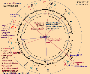 |
| Click Image To Enlarge Chart: Note: exact moment of Eruption is not known, but the time window is |
|
|
|